
The Cross-Country Area
30 km of cross-country trails, ranging from easy to difficult
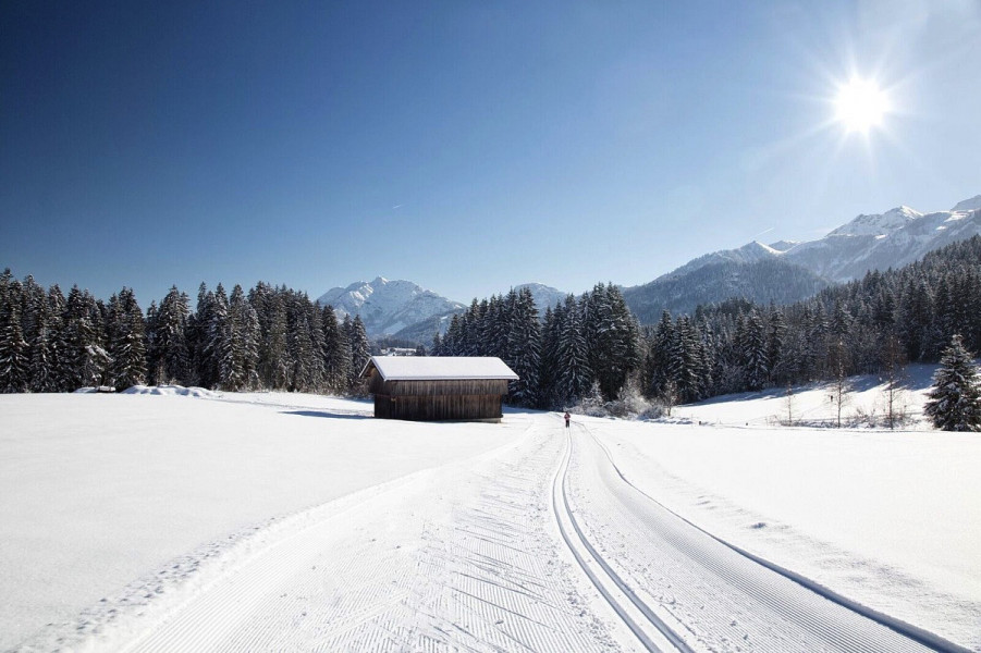
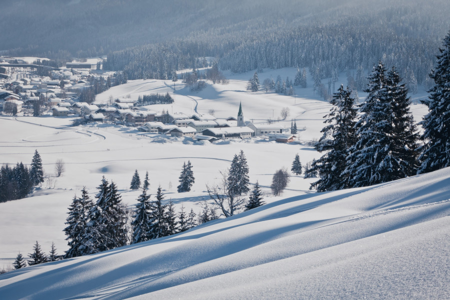
Hochfilzen is a veritable fortress of cross-country skiing. The World Cup destination is located on a high-level plateau in the pretty Tyrolean Alps. Five trails of differing difficulties extend for around 30 km in the landscape around this snow-kissed resort in Pillersee Valley, and all are groomed on a daily basis to the delight of both classic and skating skiers. It’s a great destination for both discerning as well as casual cross-country skiers, and if beginners need a helping hand, they have their choice of three cross-country skiing schools in the valley.
Biathlon World Championships in February 2017
The eyes of the sports world will once again be on Hochfilzen in 2017 when the Biathlon World Championships are staged here between 8 and 19 February 2017. It will be the third time that the town has held these illustrious championships following 1978 and 2005. On top of that, several other high-profile cross-country ski events are held annually at this high-level resort, nestled at 1000 m above sea level.
And if spectating by the side of the trails or in the shooting stadium isn't enough, you can get involved yourself in one of the weekly open biathlon competitions. These are held every Tuesday and Thursday on the Dorfloipe in Hochfilzen. You can get more information on this from the nordic academy in Hochfilzen, which is also where competitors have to register.
110 km of trails throughout the Pillersee Valley
By the way: The Pillersee Valley – which encompasses the five resorts of Hochfilzen, Fieberbrunn, St. Jakob in Haus, St. Ulrich am Pillersee and Waidring – boasts a total of 110 kilometres of cross-country trails. Almost all of these resorts are interconnected, enabling visitors to enjoy a varied cross-country skiing experience throughout the valley. Please note that the trails within the valley are fee-paying. In addition to day tickets, weekly and season passes are also available.
The Most Beautiful Tracks
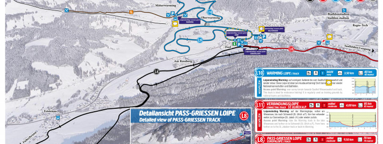
Europaloipe (no. 8)
- Total length: 15 km (with connection to Fieberbrunn 25 km)
- Difficulty: Medium/Hard
- Grooming: Two classic lanes, one skating lane
The challenging Dominik Landertinger Loipe (no. 8a), also known as the Feistenauer Loipe, is part of the Europaloipe. The trail encompasses some 95 vertical metres along its almost 5-kilometre course, topping out at an altitude of 990 metres. The first 1.5 km are downhill to Feistenau, then before the Hoferbrücke you can branch off onto the Dandlerloipe to Fieberbrunn or take the slightly uphill trail through the forest to Hochfilzen, which you should follow until the Heimkehrerkreuz. To the left you can return down to the starting point, while the trail straight on heads for Grießen (10 km).
The 10-km Pass-Grießen-Loipe (no. 8b) is also part of the Europaloipe, and 70 metres in altitude are scaled on this medium/difficult route. From the start in Grießen, the trail leads left up the hill and over the Salzburg state line to the Tödlingwirt. From there, you pass through the Spielbachwald back to Hochfilzen.
Dorfloipe (no. 9)
- Length: 3.5 km
- Difficulty: Easy
- Grooming: Two classic lanes, one skating lane
- Starting point: Town centre, between Hotel Edelweiß and the post office. The Dorfloipe only has a few minor uphill sections, making it a good choice for beginners. There is also a direct connection onto the Warminger Loipe by the railway underpass.
- Floodlit night trail: Floodlit daily until 1 AM, length: 0.8 km. This trail runs parallel to the Dorfloipe, but returns to the starting point directly before reaching the railway underpass.
Warmingloipe (no. 10)
- Length: 5 km
- Difficulty: Easy
- Grooming: Wide skating lane, three classic lanes
- Starting point: Entrance to Warmingerhof. This trail leads through sunny surroundings towards Wiesensee until you reach Gasthaus Wiesenseehof, at which point you turn back to the car park in Warming. It’s an ideal route for endurance training, and the trail of choice for national teams and pro biathletes.
Connecting trail Hochfilzen - St. Ulrich am Pillersee - St. Jakob in Haus (no. 11)
- Length: 7 km (one way)
- Difficulty: Easy/Medium/Hard
- Grooming: Classic and skating
- Starting point: The trail starts by Warming ski lift, the first section continues on the Warmingloipe and the leads straight on at GH Wiesenseehof. The route then continues on the Buchensteinwand circular trail, past the picturesque Wiesensee until Schwendt St. Ulrich. From there, you can continue on the Sonnenloipe to St. Jakob or explore the beautiful Las Valley in St. Ulrich.
Interesting facts
- Hochfilzen is among the 5 best rated Cross-Country Skiing Areas in Austria.
- The highest point of the track is 990 m above sea level.
- Snow coverage is usually best during February, offering an average base depth of 60 cm.
Video
Dining along the Tracks
There are several good places to eat and warm up in Hochfilzen. These notably include Hotel Edelweiß, Kulturhaus Chily (open from 3 PM daily), Hochfilzner Hof, Warmingerhof, Gasthaus Wiesenseehof, Café s'Häferl and "Tour Rast".
Getting Here
By car from the Munich direction:
- A8 towards Salzburg
- At the Inntal junction, exit the A8 onto the A93 (in Austria the A12) towards Innsbruck/Kufstein.
- Exit the A12 at (17) Wörgl Ost towards St. Johann in Tirol and continue on the Lofererstraße (B178) to St. Johann in Tirol.
- From here, stay on the B178 to Pillerseetal/Waidring, or turn onto the B164 to Hochfilzen.
By car from the Innsbruck direction:
- From Innsbruck on the A12 towards Salzburg / Germany.
- Exit the A12 at (17) Wörgl Ost towards St. Johann in Tirol and continue on the Lofererstraße (B178) to St. Johann in Tirol.
- From here stay on the B178 to Pillerseetal/Waidring, or switch onto the B164 to Hochfilzen.
By car from the Salzburg direction:
- Take the A1 or A10 to the "Salzburg West" exit or the A8 over the Austrian border to the “Bad Reichenhall” exit.
- Follow the B178 towards Lofer and Innsbruck.
- In Waidring, turn left towards Pillersee and Hochfilzen.

