
The Cross-Country Area
In the cross-country skiing area of Méribel - Courchevel - La Tania, a network of 115 kilometres of prepared trails awaits you. The tours lead you through impressive natural landscapes such as the protected area of See Tuéda or the forest area near Altiport. With different levels of difficulty, there is plenty to offer for cross-country skiing professionals but also for beginners.
Those who want to ski around the lake have the choice between a circular trail marked as easy with a length of three kilometres or the somewhat more demanding and longer trail, which also leads through the forest and comes to five kilometres and an ascent of 100 metres. If you dare to do longer tours after these routes, it is best to go to Altiport. Here you will find three more easy trails, but also a technically challenging trail of ten kilometres, as well as a trail to Courchevel (17 kilometres) or La Tania (16 kilometres).
The Most Beautiful Tracks
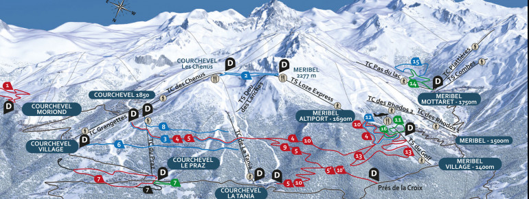
Overview of the trails in the cross-country skiing area Méribel - Courchevel - La Tania
Easy trails:
- Trail no. 7: 1.5 kilometres - 20 metres altitude difference
- Trail no. 11: 1.5 kilometres - 25 metres altitude difference
- Trail no. 14: 3 kilometres - 20 metres in altitude
- Trail no. 16: 1.5 kilometres - 10 metres in altitude
medium difficulty trails:
- Trail no. 2: 1.8 kilometres - 60 metres altitude difference
- Trail no. 3: 5 kilometres - 80 metres altitude difference
- Trail no. 6: 5 kilometres - 135 metres altitude difference
- Trail no. 8: 4 kilometres - 60 metres in altitude
- Trail no. 12: 5 kilometres - 110 metres altitude difference
- Trail no. 15: 5 kilometres - 100 metres altitude difference
difficult trails:
- Trail no. 1: 4.5 kilometres - 90 metres altitude difference
- Trail no. 4: 17 kilometres - 400 metres altitude difference
- Trail no. 5: 13.5 kilometres - 360 metres altitude difference
- Trail no. 7: 4.8 kilometres - 100 metres altitude difference
- Trail no. 9: 8 kilometres - 300 metres altitude difference
- Trail no. 10: 18 kilometres - 520 metres altitude difference
- Trail no. 13: 10 kilometres - 230 metres altitude difference
Interesting facts
- Offering 115.10 km cross-country trails, Meribel is among the 10 largest Cross-Country Skiing Areas in France.
- Elevated between 1,400 m and 1,850 m, the Cross-Country Skiing Area is among the 10 highest elevated Cross-Country Skiing Areas in France.
- Snow coverage is usually best during March, offering an average snow depth of 202 cm at summit elevation and 93 cm at the base. Therefore Meribel is among the 10 cross-Country Skiing Areas with best snow conditions in France.
Video
Getting Here
By car
- If you are travelling by car, take the A41 from Grenoble to the A43/E70 Turin/Albertville/Milan exit. Follow the N90 to Moûtiers. Continue on the D915 and at Brides-les-Bains change to the D90, which leads to Méribel.
By train
- The TGV goes to Albertville or Moûtiers. From there, buses go to Méribel.